Brevet-400km
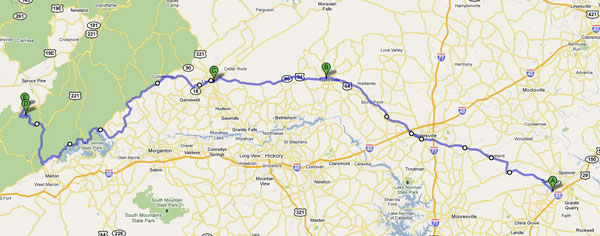
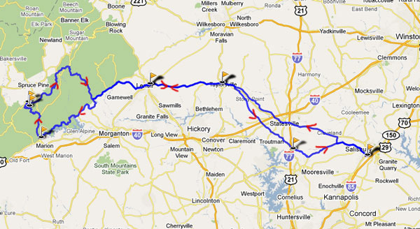
Salisbury, Lenoir, Adako, Marion, Little Switzerland, Parkway North, Linville Falls, Lenoir, Troutman, Salisbury
July 3-4th, 2010 Brevet 400k Salisbury-Little Switzerland-Salisbury, NC
Distance for the complete loop is approximately 417 Kilometers (259 miles with a fair amount of climbing in the middle)
Distance for Salisbury, NC 400k is approximately 417 Kilometers 259 miles
Brevets starts at Mar 6, 2010 06:00 AM
The routes are in the Piedmont and Mountain area of NC so they are rolling to hilly.
Pre-Registration is strongly recommended for all events! If you do not pre-register your start may delayed or you may not be able to get credit for the brevet.
The route is somewhat of a challenging route in places due to the terrain, but not such that most reasonably fit randonneurs would not be able to finish on time. Some of you may need a triple or low gear compact. You will need to watch your stop times and site seeing times, so consider planning to keep a steady effort on the easier section which you have a good bit of in the first 100 miles and there are quite a few long down hills too. Please save some energy for the middle section and the last section of long rollers.
Currently there are 9 controls, 1 of them an info control. Remember: Secret controls are still a possibility, so you'll need to stop, write the info and time on your card and then go on at the info controls.
There are good food stops available on route in Lenoir (2 or 3 places depending on when you get to Lenoir), if is hot stop at store in Colletesville, In Marion 1 mile off course South on 221, the Alpine Inn on 226A one mile before top said you could stop there for a break if you need it on the 226A climb, Little Switzerland (2 places, close at 8pm), Lenoir, Taylorsville and Troutman truckstop NC-115 & I-77 There are a few other stores on route.
On Site Registration/inspection opens June 5th 2010 about 05:00am
Windsong Bicycle Shop
on Hwy 601 N - 2702 S. Main St. Salisbury, NC
Brevet starts at July 3rd 2010 06:00 AM
July 3rd 2010 • Sunrise 6:03 AM • Sunset 8:32 PM • 14h 29m of daylight • EST
July 4th 2010 • Sunrise 6:04 AM • Sunset 8:34 PM • 14h 30m of daylight • EST
If you have not completed the brevet by sunset you must have RUSA approved lights and reflective gear on and operational or you will receive a DNF for the brevet.
Suggested donation
400k = $40 per rider
Brevets are generally not races for which there is no prize money, so please be polite to all volunteers, fellow riders and convenience store attendants. Helping a fellow rider to finish is allowed and should make you feel better.
The spirit of randonneuring emphasizes self sufficiency. Personal sag vehicles are not allowed on the course and can only be used in certain situations defined in RUSA's Rules For Riders. You should also follow all local traffic laws, rules & regulations while participating in any brevet.
Please ensure that you dress appropriately for the weather conditions and have sufficient supplies and extra funds if needed for anything that may arise while en route on brevets!
Riders should pre-register online to allow them to start on time. You may also be able to register at the event prior to the start. It is strongly suggested that you pre-register. If you do not pre-register, your start may delayed or you may not be able to start with the other riders. Day of event registration may close at before the official event start time for Brevets.
This is an ACP-RUSA Brevet route number 698. The total time allowed from start to finish is 13.5 hours. The actual distance is approximately 206 Kilometers. Riders must follow and complete the approved route. This route goes through several small towns in central North Carolina traveling along mostly low traffic roads. There may be some sections where traffic is high, so please ride carefully and safely at all times. The intermediate controls are at the Charles, N. Wilkesboro & Charles where stores allow you to refuel with some basic supplies. There are also some other stores along the route where you may be able to stop and get limited nutritional supplies.
This is a basic route map. Please note that all online images, que sheets and maps are for general reference. Offical routes will be provided at the event start for registered participants. Anoter map version is available by clicking on either map.
Approximate overall climbing is about 16,000 feet using Garmin
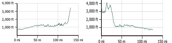
Climb up 226 and 226A Marion to Little Switzerland
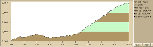
expect to take close to 2 hours to travel this section.
400k Que sheets
For gpx files and active map go to
http://www.trimbleoutdoors.com/ViewTrip/701367
Start location will be at Windsong Bicycle Shop - Salisbury, NC
View Larger Map